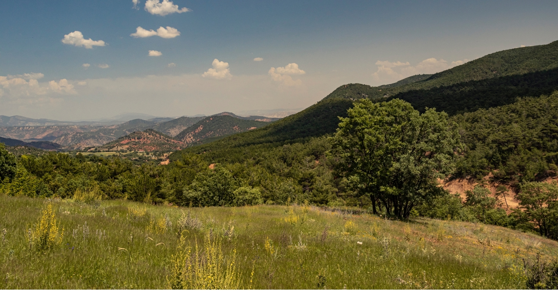
Hill Country's rolling terrain, dense oak cover, and rugged limestone outcrops have always been tough on land surveyors. Traditional methods mean days fighting through cedar breaks, navigating steep slopes, and dealing with property access headaches. Drone mapping solves these problems by delivering complete site coverage in hours while keeping crews safe and productive.
Surveyors working across the Texas Hill Country deal with conditions that make ground-based work inefficient and sometimes dangerous. The region's geology presents challenges that drone technology naturally addresses, from limestone bedrock that complicates equipment setup to vegetation that blocks sightlines and conceals terrain features.
In this guide, we'll break down the specific Hill Country conditions that slow traditional surveying, explain how drone technology addresses each challenge, and show why firms serving this market are adopting airborne systems as standard practice rather than occasional solutions.
How Hill Country Terrain Slows Traditional Surveying
Steep Elevation Changes
Hill Country topography fights you at every turn. Properties routinely drop or climb 100 feet within short distances, killing sightlines and forcing crews to establish multiple control points just to maintain accuracy. What looks straightforward from the office becomes a multi-day test when you're hauling total stations and GPS rovers up limestone hills in Texas heat.
Drone-based LiDAR systems skip the hiking. Aircraft capture elevation data across entire properties in a single flight, maintaining consistent accuracy whether the terrain is flat, vertical, or completely inaccessible on foot.
READ MORE: Comparing Industrial Drones? Don't Just Look at Flight Time
Exposed Limestone Bedrock
The Edwards Plateau limestone that defines this region creates real problems for ground equipment. GPS rovers can't lock stable positions on exposed rock. Tripods won't anchor in shallow soil over bedrock. Even hard limestone surfaces scatter and distort terrestrial laser returns.
When equipment won't position properly, measurements suffer, forcing extra verification that stretches timelines. Airborne systems map from above, where limestone outcrops become documented features instead of equipment obstacles.
Dense Canopy Cover
Cedar, live oak, and juniper create a canopy so thick that visual surveying becomes nearly impossible across large sections. Traditional land surveying methods require extensive brush clearing before work begins, which adds costs and potentially triggers environmental compliance issues on properties with conservation easements.
Industrial, survey-grade drone platforms equipped with LiDAR punch through vegetation to map the actual ground surface underneath. This reveals terrain features, drainage patterns, and site characteristics that stay hidden from ground-level observation, but without massive site disturbance.
Property Access Issues
Large Ranch Properties
Hill Country projects often involve large ranch properties where basic site access becomes a logistics puzzle. Hundreds or thousands of acres mean field crews spend more time moving equipment than collecting data. Remote locations mean longer drives from the office, limited backup when equipment fails, and communication problems that slow everything down.
Drone surveying compresses these headaches into manageable timeframes. One field visit captures data that would otherwise require multiple trips, cutting fuel costs, crew hours, and coordination hassles.
Boundary Disputes and Landowner Relations
Many properties lack formal access easements or established entry points. Getting permission to cross neighboring land just to reach your work area adds complexity and delay. Boundary work in Hill Country often involves disputes over historic fence lines, conflicting deed descriptions, and questions about whether monuments were ever correctly set.
High-resolution orthoimagery from flights provides objective visual records that help resolve questions before they escalate. Landowners see exactly what's being documented and how determinations were made, reducing conflicts and backing professional opinions with clear evidence.
READ MORE: What Are the Different Drone Capabilities? LiDAR, Orthoimagery & Linework Explained
Environmental Conditions
Extreme Heat
Summer temperatures regularly exceed 100 degrees, creating legitimate safety risks for field crews working in exposed conditions while carrying heavy equipment. Aircraft operations allow crews to work more efficiently with less exposure.
Flight planning happens in air-conditioned vehicles, and active fieldwork involves monitoring equipment rather than hiking rugged terrain in extreme heat.
Flash Flooding in Creek Drainages
Properties often include creek drainages and flood-prone areas, presenting real hazards. The region's geology creates rapid runoff, which can lead to flash floods developing with little warning, particularly during spring and fall storms.
Airborne systems document these areas completely, without putting anyone at risk, capturing detailed terrain data that reveals flood characteristics and drainage patterns essential for development planning.
Wildlife Hazards
Hill Country wildlife creates considerations that slow traditional work. Feral hogs damage monuments and create hazardous ground conditions. Rattlesnakes inhabit exactly the rocky areas and brushy thickets where work is done.
Property hazards, such as barbed wire, hunting blinds, and ranch infrastructure, require constant attention. Aircraft operations minimize these risks by reducing the time crews spend navigating hazardous terrain.
Market Pressures
Hill Country property values and development interest have climbed substantially. Buyers expect comprehensive intelligence before closing, and timelines have compressed as competition intensifies. Firms delivering faster results win more business.
Developers and engineers working here increasingly specify airborne data for project planning. They've experienced the benefits of comprehensive coverage, precise elevation models, and CAD-ready deliverables integrating directly with design workflows.
Firms that can't provide this capability risk losing projects to competitors who've adopted it.
Why Local Knowledge Matters
Understanding Hill Country conditions requires more than technical skill. It demands experience with the region's specific challenges. Surveyors who are familiar with the terrain, geology, and property characteristics make more informed decisions about methods, equipment deployment, and data collection strategies.
This local knowledge becomes even more valuable when applying advanced technology.
Conclusion
Hill Country projects present challenges that ground methods struggle to overcome efficiently. Steep terrain, dense vegetation, rocky geology, and access limitations create conditions where airborne mapping delivers measurable advantages in project speed, data quality, and crew safety.
Firms serving this market now see these capabilities as essential rather than optional. The technology captures coverage across difficult terrain while reducing field time, minimizing unsafe exposure, and delivering the complete site intelligence clients expect.
SmartDrone, based in Texas, works with surveying firms navigating Hill Country's specific conditions every week. We understand the limestone that wrecks equipment positioning, the ranch access issues that stretch timelines, and the vegetation that makes traditional methods impractical.
Contact SmartDrone to discuss how drone mapping addresses the specific surveying challenges your firm faces in the Texas Hill Country.

.jpg)