.png)
Every platform demos well. Vendors run them on clean sites, open terrain, and straightforward deliverables, and under those conditions, the differences between systems are almost impossible to see. The problems surface later, on actual projects, when the terrain is vegetated and complex, and the deliverable has to land in an engineer's hands without a reformatting step in between.
By then, the purchase is already made. What would have separated a good platform from a poor fit was never visible on a sales sheet, and it rarely comes up in a demo. Knowing what to ask before that conversation starts is what keeps the decision from landing on the wrong criteria entirely.
READ MORE: When Drone Surveying Makes Sense for Your PLS Project
What Engineers Actually Need From the Deliverable
The Distance Between Raw Data and a Usable File
Engineers do not work with raw LiDAR files. They need spot ground elevations at client-specified intervals in state plane coordinates tied to the correct geoid, orthomosaics that meet resolution thresholds for the intended use, and linework that opens in Civil 3D without a conversion step that adds time and introduces error on every project.
That distance between what a platform produces and what an engineer can actually use varies considerably, and evaluation rarely surfaces it. Vendors build demos around datasets that bypass the reformatting step entirely. In production, that step shows up on every project.
Why Generic Platforms Fall Short for Survey Work
Generic drone data processing software is built for inspections, real estate documentation, and construction progress monitoring. Survey-grade deliverable production requires something more specific, and platforms built for broader markets tend to treat output format as secondary rather than a core function.
Before anything else in a software comparison, get a direct answer on what formats the platform delivers natively and how base-station coordinate confirmation works inside the workflow. If that answer requires digging through documentation rather than a straightforward conversation with someone technical, that signals how the platform was designed and for whom.
How Ground Classification Separates Platforms on Complex Terrain
Why Published Specs Do Not Reflect Production Performance
LiDAR penetrates vegetation canopy to map the ground surface beneath it, but classification accuracy on complex terrain determines whether that data is usable. Algorithms vary significantly in ways that published specifications do not capture.
A platform that performs cleanly on open ground can produce inconsistent ground models on a forested parcel with mixed vegetation density and variable slope. In survey work, that is not a rare scenario. It is a routine one, and platforms that struggle there reveal it on production jobs rather than in controlled benchmarks.
How to Evaluate Classification Before You Commit
Testing against a vendor's benchmark gives limited information. A more reliable approach is to run a dataset from your project types through the platform's classification workflow, with parameters adjusted to your actual terrain conditions. Sample data from production jobs reveals performance that controlled benchmarks are not designed to show.
Adjustable classification parameters matter here, too. A platform that gives operators terrain-specific control over output quality handles the variability of real projects in ways that fixed settings built for broad compatibility simply cannot match.
READ MORE: What Are the Different Drone Capabilities? LiDAR, Orthoimagery & Linework Explained
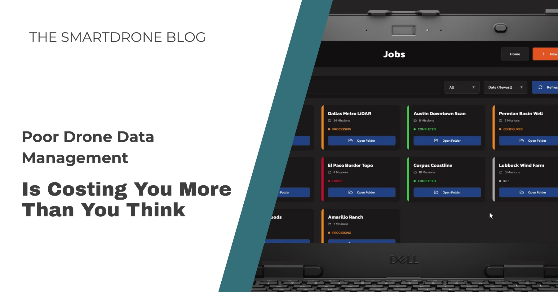
The Post-Flight Coordination Overhead Nobody Audits
Where Time Goes After the Flight
Most surveying operations evaluate drone data management software on what it does to the data. Fewer evaluate what it does to the people managing that data, and that is usually where the real cost sits. File organization, processing handoffs, third-party processor routing, and deliverable version tracking all default to informal systems when the software does not handle them.
Those systems hold up under a light project load. Under a normal one, they break down in ways that are difficult to trace to any single failure because the overhead spreads across every project rather than sitting in a single, visible place.
What Centralized Visibility Changes
When no single place exists to see which jobs are in queue, which are waiting on a processor, or which deliverable version a client needs, the team absorbs coordination work into the general workload, and it disappears from project estimates entirely. Operations running several active projects simultaneously are most exposed. Each project develops its own informal tracking logic, and that logic breaks the moment someone is out, a processor comes back with questions, or a client calls about a revision.
When project management is part of the processing platform rather than handled alongside it, job status is visible without a phone call, and handoffs move through the system rather than an email thread no one can locate. Buying processing software and managing workflow separately produces two partial solutions, not one complete one.
The Field Verification Step Most Evaluations Skip
Why Return Trips Keep Happening
A coverage gap that surfaces during office processing means a return trip. A base station that stopped recording mid-flight produces the same result. In both cases, the crew had everything needed to catch the problem before leaving the site, but most operations have never built field verification into their standard process. Without a designated step, the check is not consistent, and the return trips continue.
What On-Site Review Actually Prevents
Software that supports on-site data review enables crews to check coverage completeness, confirm base station performance, and review flight metrics before packing out. The problems that generate return trips are rarely complicated. A missed overlap area, a gap in base station recording, a flight path that clipped a property boundary: all straightforward to address in the field, and considerably harder to resolve from the office two days later.
For operations managing several concurrent projects, reducing even a fraction of those trips across a full season produces measurable margin recovery. It does not show up on a sales sheet comparison. It shows up in project profitability at year-end.
READ MORE: Comparing Industrial Drones? Don't Just Look at Flight Time
The Costs That Only Show Up After You Commit
How Integration Affects Everything Upstream
The deliverable quality, classification accuracy, and field verification capability covered in the previous sections do not exist independently of the hardware the software runs on. Processing software designed for a specific hardware platform handles coordinate confirmation, base station workflows, and output calibration based on how that sensor actually captures data.
General-purpose platforms are built for compatibility across many configurations, so no single one is prioritized. For operations where output precision and pipeline reliability matter on every project, that distinction shows up in the work.
What the Platform Actually Costs to Run
The return trips, coordination overhead, and reformatting steps this piece describes all carry costs that never appear on a pricing page. Neither does the full picture of what a platform charges at production volume.
Base monthly rates shift considerably once per-seat licensing, per-job processing fees, and separately priced field verification tools are included. Before committing, confirm what is covered at your actual project load and whether the license is perpetual or renews annually. The operational cost of software that does not fit how your operation runs is often higher than any line-item comparison would indicate.
Conclusion
Most surveyors treat their software as a purchasing decision. Over time, however, it acts like a structural one, because the platform shapes how the entire operation runs:
- How data moves from the field.
- How projects get tracked.
- How handoffs happen.
- How consistently work gets out the door on time.
The firms running the tightest operations are not always the ones with the newest equipment or the largest crews. They built clean workflows early and have been compounding that advantage on every project since. That process starts with software designed around how survey work actually runs, and it shows in the margins by the end of every season.
Evaluating drone survey software for your operation? Contact SmartDrone with your current setup and project volume. We'll walk through how Pulse and Magellan work together from day one.
.jpg)
.jpg)